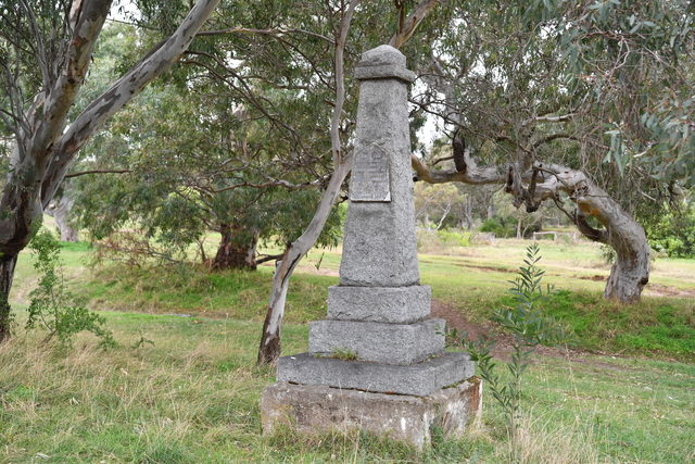
In 1824 adventurers Hamilton Hume and William Hovell set off from Sydney to find new grazing land in the south and an overland route to Westernport. In December of that year, the explorers set up a base camp near where Tullamarine Airport is now located. A dry-stone triangular monument dated 14 December – 20 December 1824, stands erected and sadly neglected in the grass fringe beside Oaklands Road, Greenvale, as a historical reminder of the expedition passing through the City of Hume. Peter Whelan charts the incredible journey of Hume and Hovell on the expedition’s 200th anniversary.
On October 17 1824, Hamilton Hume, aged 27, an Australian born farmer and bushman, and William Hovell, a 38 year old retired English sea captain, left Gunning near Yass on an adventure into the unknown. They had been commissioned by the NSW government to find an overland route to Westernport in Victoria. They were to share the leadership. Even though the Blue Mountains had been crossed in 1813, what existed further south and west was unknown to this struggling infant nation. A popular opinion amongst many was that of an inland sea existing somewhere beyond and yet to be discovered.
The party would include six convicts, three each assigned to each leader. Colonial funding under Governor Sir Thomas Brisbane, was modest in the form of six pack saddles, one tent, two tarpaulins, a few bush utensils, a small quantity of arms and ammunition and importantly … two skeleton charts on which they were to trace their journey. Otherwise, the expedition was self-funded. Hume supplied his own resources that included selling farming implements to pay for supplies. Hovell did likewise. Their livestock consisted of three horses and five bullocks. The carts would be loaded with supplies and driven by the bullocks. Each man would be provided with a musket; and Hume brought along his kangaroo dogs to run down meat. Hume also provided food rations and equipment loaded into drays and stored within certain outstation huts for replenishment on the return journey to sustain them.
Hume was an adventurous optimist, whereas Hovell was a dour pessimist. These characteristic differences were exposed on the third day when the party came across the flooded Murrumbidgee River. After three days of waiting for the flooded river level to subside, and with time precious, Hume decided to attempt a crossing. Hovell objected deeming the fast flowing waters too dangerous to attempt. Hume trusted his judgment and succeeded in making the crossing. Pressing onward the party experienced great hardship crossing the unknown snowy mountains.
On November 16 Hume returned to camp in a joyous mood. He had been scouting ahead of the party and had discovered a mighty stream in flood far bigger than the Murrumbidgee. He had decided to name it after his father Arthur Hamilton Hume. He logged it on the skeleton map as ‘The Hume River.’ The mighty river would later be renamed the Murray by Captain Charles Stuart.
From November 16 until December 14 – the day the party arrived near Tullamarine Airport and set up what turned out to be a six- day base camp – the expedition discovered the Mitta Mitta, Kiewa, Ovens, and Goulburn rivers, onward from Yea and Flowerdale. The expedition encountered the worst four days of terrain yet, and spent that time unsuccessfully searching for the summit of a mountain hoping to glimpse the sea. But they were well off course. But eventually Hume guided the party back on course to Strath Creek and Broadford to open land. Hume called the scrub, rough and stony ground they trudged, and tall sword grass they cut through an impregnable barricade. He named its peak Mt Disappointment, a name still relevant today.
From Broadford they turned south toward Kilmore and tramped on to Beveridge. There Hume climbed a steep and densely wooded hill now known as Mount Fraser, and to the joy of all sighted the sea in the distance. The next day, December 14, they set up a base camp near Tullamarine Airport where they rested, confident their objective was in sight.
The next day the team continued south-west through Bulla, St Albans, and Werribee . They encountered several rivers, the Maribyrnong, Kororoit, and Werribee. Hume was scouting ahead again and had a hunch the surrounding topography he was tramping through had a natural slope towards the coast. He was right. The following day they all delighted at sighting the sea. They had reached the halfway mark of their objective … now to turn around and return home.
On Monday 20 December, they returned to the campsite they had previously used heading south. Hume’s plan was to complete the journey in a circle by heading west of their original course to avoid a forest of tangled gullies and steep ridges; multiple streams and barriers of mountain ranges. By then their remaining supplies were of only 150 pounds of flour, six pounds of tea, and no sugar and salt. And facing them at least 700 kilometres across country stripped by Aboriginal land burning and in the baking heat of an extremely hot December.
By Thursday 23 December they had reached the Goulburn River, 30 kilometres west of their earlier crossing point. To do this they had kept a range of mountains to their left. Hume named and recorded the range as Mount Wentworth in honour of his fellow explorer and friend William Wentworth. Later the range was renamed Mount Macedon by another explorer Thomas Mitchell.
On 27 December, they passed over the Wombat Rangers. Two days later they crossed the Ovens River. By 3 January 1825, they reached the Hume (Murray) River. They were able to comfortably cross and give the tired horses and cattle time to eat and rest. The men were suffering in the baking heat with their clothing in rags, the flies almost unbearable, and the livestock increasingly footsore and lame.
On Wednesday 5 January, despite their deteriorating condition, they were still able to advance almost 30 kilometres. By now the kangaroo dogs were lame and Hume’s ammunition was almost expended. On Saturday, 8 January they consumed the last of their travelling rations. The stock was crippled and almost exhausted. The convicts were little better, with their boots worn through they could hardly hobble behind the leaders.
On the morning of 9 January, Hume calculated to reach food stored at the outstation hut he would have to turn east and into the mountains. It was that or perish. The hide was used to wrap their feet for some comfort, as well as fashioning into moccasins for the lamest bullocks. Bravely they staggered on.
By Friday 14 January, they travelled along a ridge through very rough country, sometimes staggering over steep crags, loose stones, gullies, steep ravines traversed by small streams. Hume’s dog had to be put down. Despite unimaginable suffering, the remaining members of the party pressed on. And then they saw it. Hume’s outstation supply depot almost as they had left it, apart from a ripped tarpaulin, and a small keg of spirits that had rotted away over time and leaked out. They had found the food dray with the supply of salt pork untouched a fit to eat.
What remained of the party reached Sydney on Tuesday 24 January 1825. After 16 weeks of relentless slogging, and remarkably with only a five week turnaround, they had all returned to ‘Sydney Town’ where the expedition had started. Hume and Hovell had completed their mission without losing a man. And Hamilton Hume had become Australia’s first Australian born explorer.
For his services Hume received a grant of 1200 acres of land, which he was forced to sell to pay outstanding expenses. A happier homecoming was his marriage soon after to Elizabeth Dight of Richmond
And of course there was no ‘inland sea’. It was a wild fictitious dream as Hume continuously advocated.
Note: Later a party, including Hovell, was sent by sea to Westernport. It was then that Hovell realised that the earlier expedition had found Corio Bay in Port Phillip, not Westernport.

